wether its 2012 ,government cover ups,Anonymous,reptile people ,illuminati,monsters yellowstone national park,yellowstone hotel the doomsday clock ,adolph hitler + a lot more (never let the truth get in the way of a good conspiracy)Please Donate and Help me Maintain this Blog to Enable me to Dig Out More and better Theories
................(Also Incorporating Spirit2009)
The devestation is Bad and the news doesn,t even give credit to the pain and suffering this great nation has endured ,watch this clip and think there by the grace of god goes i.
As news emerged today of yet another earthquake striking Japan, terrifying new footage from the original March 11 earthquake and tsunami shows the brutal and deadly power of the water that has claimed thousands of lives.
Filmed from the top of a building in Kesennuma, around 300 miles north-east of Tokyo, the footage shows the surge of water cascading over coastline barriers around Kesennuma Bay as a tsunami alarm sounds.
It quickly turns into a furious torrent of water, sweeping everything away - including cars, ships and buildings - as it forces itself inland.
Soon the wall of water is moving with incredible speed and rising fast - the barrier that had once looked like a mini waterfall is now now merely a ripple as the tide flows over it.
A storage building with a green roof in the middle distance of the shot begins to disintegrate under the immense force.
Map
The camera pans to the right and focusses on another part of the city. Water can be seen flooding surrounding streets and buildings in the distance are being washed away as smoke rises from the ravaged city.
What was once the carpark below the cameraman's vantage point is now a boiling and deadly body of water.
The unstoppable surge brings down power lines and street lights and then the green-roofed building breaks from its foundations and crashes into a multi-storey building in the foreground - spewing its contents into the surge as it is torn apart.
The cameraman pans right again and shows the full destruction of Kesennuma - the city is now reduced to partially submerged and shattered buildings.
Japanese authorities and the U.S. Geological Survey today announced that another quake, measuring 6.5 in magnitude earthquake hit off the northeast coast of Japan today.
It is also in the Miyagi prefecture, where Kesennuma and many other cities and villages once stood.
The Japan Meteorological Agency issued a tsunami warning for the Pacific coast of Miyagi prefecture, But the warning was later withdrawn.
Unbeknown to Americans there are secret deep undergound bases thoughout america all joined up and awaiting the one catastrophy that will surpass all major disasters so far they are based to house the elite of the elite and have enough food supplies and oxygen to last quite a few years ,the oxygen is not reliant on the outside and can be all self sufficent it has numerous chambers all with built in toilet facilities and lockable doors and storage ,there is also tv and leisure rooms and trams with transportation to take you anywhere everything is ready all that is awaiting is the disaster which according to the NWO is imminent there are different views from google that have bits cut out so we the common mortals can't see ,we will be paying our taxes and bills as normal even when these people find out and are safe tucked away waiting ,all that will happen with us is we look up and see the danger ,no warning ,no time to be with our loved ones nothing except the knowledge that at least our council tax ,and income taxes are upto date .
New York City
There is an entrance to the tunnels in New York City "in the vicinity of Midtown Manhattan that can be reached through an abandoned elevator shaft that only very few know about
The Nahanni Valley (Canada) Entrance
This covers 250 square miles in the southern end of the Mackenzie Mountains of Canada. It lies almost 550 miles due west of Fort Simpson on the Mackenzie River of northwest Canada. Hot springs and sulfur geysers keep the valley warmer than the surrounding areas by about 30 degrees year -round (the valley is above 60 degrees latitude), making it perpetually mist-covered. This valley is inhabited only by animals as people entering the valley are usually found headless and quite dead. The Indian tribes of the area avoid this valley. (These tribes include the Ojibways, the Slave, the Dogribs, the Stoney, the Beavers and the Chipweyans.) This valley is often referred to as "the Valley of the Headless Men.
The Liyobaa Cave Entrance
This was sealed off by Catholic Priests who believed it to be an entrance to "Hell." "The village of 'Liyobaa' or to translate, 'The Cavern of Death,' was located in the province of Zapoteca, somewhere near the ancient village of 'Mictlan' or the village of the 'Underworld.
"The Cavern of Death was actually located in the last chamber of an eight chamber building or temple. This temple had four rooms above the ground and four more important chambers built below the surface of the Earth. This building was located in "Theozapotlan," and the tunnel entrance led one beneath a mountain.
The Maltese Cave Entrance
This entrance is located on the island of Malta, near the small village of "Casal Paula." (This village is built on the "Corradino" plateau, and overlooks the capitol town of Malta, "Valletta," as well as Grand Harbour.) In 1902, workmen digging a well in Casal Paula fell into a subterranean cavern. The well was being dug for a house on "Hal Saflienti," the main street in Casal Paula. The cavern the workers had fallen into connected with an entire complex of caves and tunnels. This entrance is known as the "Hypogeum of Hal Saflienti." (In Latin, "Hypogeum" is the name for an underground structure.) "The tunnels under the Hypogeum have been sealed off even since a school took 30 students into the caves and disappeared, guide and all. Search parties were never able to locate any trace of the people and children.
The Staffordshire, England Entrance
Somewhere in Staffordshire, England, a lonely field exists in which a laborer discovered a large iron plate beneath the dirt. The "hatch" was large and oval, with an iron ring mounted on it. This entrance led into the tunnels. The field is in a valley surrounded on almost all sides by woods. The laborer was digging a trench for some purpose. The incident was reported in "A History of Staffordshire" by Dr. Plot, who wrote the book in the late 1700s. It may be possible to find the entrance if it can be ascertained exactly which valley the laborer was digging in.
The Dulce, New Mexico Base
An underground Military Base/Laboratory in Dulce, New Mexico connects with the underground network of tunnels which honeycombs our planet, and the lower levels of this base are allegedly under the control of Inner Earth beings or Aliens. This base is connected to Los Alamos research facilities via an underground "tube-shuttle." (It can be assumed that such a shuttle way would be a straight-line construction. It should then be possible, by using maps and some deduction, to determine the most likely location of this base, especially since the general location is already known.) Beginning in 1947, a road was built near the Dulce Base, under the cover of a lumber company. No lumber was ever hauled, and the road was later destroyed. Navajo Dam is the Dulce Base's main source of power, though a second source is in El Vado (which is also another entrance). (Note: The above facts should also help to locate the base.) Most of the lakes near Dulce were made via government grants "for" the Indians. (Note: The September, 1983 issue of Omni (Pg. 80) has a color drawing of 'The Subterrene,' the Los Alamos nuclear-powered tunnel machine that burrows through the rock, deep underground, by heating whatever stone it encounters into molten rock, which cools after the Subterrene has moved on. The result is a tunnel with a smooth, glazing lining.)" (Note: Where would the molten rock go? And what has been done with this concept since 1983?)
Bechtel (BECK-tul) is a super secret international corporate octopus, founded in 1898. Some say the firm is really a 'Shadow Government's working arm of the CIA. It is the largest Construction and Engineering outfit in the U.S.A and the World (and some say, beyond)." "The most important posts in U.S.A. Government are held by former Bechtel Officers. There are over 100 Secret Exits near and around Dulce. Many around Archuleta Mesa, others to the source around Dulce Lake and even as far east as Lindrich. Deep sections of the Complex connect into natural Cavern Systems. (Note: The elevators, lights, and doors at Dulce Base are all magnetically controlled.)
The area around Dulce has had a high number of reported Animal Mutilations." The researchers at Dulce Base have also abducted several people from Dulce's civilian population and implanted devices of various types in their heads and bodies. (Note: Livermore Berkeley Labs (where?) began producing blood for the Dulce Base in the mid 1980s, and Human and Animal abductions slowed considerably. It may be worthwhile to check-out Livermore Berkeley Labs.) DELTA group (from the National Recon Group) is responsible for security of all Alien-connected projects. The DELTA symbol is a Black Triangle on a Red Background. Dulce Base's symbol is a Delta (triangle) with the Greek Letter "Tau" (t) within it, and then the entire symbol is inverted, so the triangle points down, and the "Tau" is also inverted. Christa Tilton (was abducted and taken to Dulce Base) She is the editor of "Crux" magazine, which deals with UFOs, abductions, etc. P.O. Box 906237 Tulsa, Oklahoma (zip ?????)
Bases in the United States Mt. Ranier, Washington State Mt. Lassen, Tehama County, California Death Valley, California Superstition Mountains, Arizona Mt. Shasta, California Brown Mountain, North Carolina Mt. Ranier Entrance.
A very active UFO base exists beneath Mt. Ranier. There are also said to be underground "vaults" containing records of the ancient Lemurians. (Note: F.L. Boschke wrote the book "The Unexplained" about the mysteries surrounding Mt. Ranier.) The ice cap of Mt. Ranier contains a maze of corridors and caves. In August of 1970, scientists climbed to the top of Mt. Ranier, and entered these caverns and tunnels. Evidence was found indicating that a small lake exists deep beneath the ice cap. It is possible that one could find a way to get beneath Mt. Ranier through these tunnels.
The Mt. Lassen Entrance Mt. Lassen in Tehama County, California is an entrance to a large underground city. Near the foot of Mt. Lassen is a town called Manten. A man named "Ralph B. Fields" lived (lives?) there, and found the entrance to the underground city. His friend "Joe" was with him. The cave entrance is in the side of the mountain, at a little over 7,000 feet above sea level, and is near a rock outcropping suitable for camping under.
Death Valley, CA. Entrance.
Local Indian legends speak of a tunnel that runs beneath the desert. (Note: The book "Death Valley Men," tells the story of 3 people who are supposed to have found an underground city connected with this tunnel, and who actually took treasures from it. The entrance to the Death Valley Tunnel is in the Panamint Mountains down on the lower edge of the range near Wingate Pass, in the bottom of an old abandoned shaft. The bottom of the shaft is collapsed, opening an entrance into a large tunnel system containing much treasure. These tunnels connect with the surface also through arches (like large windows) in the side of the mountain and they look down on Death Valley. They're high above the valley now, but they were once on the edge of the water, and were accessed by boats. The "windows" in the Death Valley side of the Panamint Mountains are about 4,500-5,000 feet above the bottom of Death Valley, and are across from Furnace Creek Ranch. From these openings you can see the green of the ranch below you and Furnace Creek Wash across the valley. (So, with high-powered binoculars or a telescope, you should be able to see the openings from the Furnace Creek Ranch, or Wash.) You can drive down Emigrant Canyon towards Death Valley. You can then park beside the road between Furnace Creek Ranch and the Salt Bed. (From here, the windows should be visible through binoculars.) Indian legends of the Paiutes Indians speak of the people who used to live in the Panamint's caverns.
The Mt. Shasta, CA Entrance
There are tunnels beneath Mt. Shasta that lead to a UFO base there, as well as tunnels that connect with the vast world-wide tunnel network. The Lemurian city "Telos" is said to exist beneath Mt. Shasta. William Hamilton has done much research on Mt. Shasta and the tunnels. He has privately published a book entitled "Alien Magic" 249 North Brand Boulevard, Suite 651 Glendale, CA 91203
The Brown Mountain Entrance
Brown Mountain is in North Carolina near Morganton. Morganton is "about 15 miles north of an actual highway marker which has been posted by the state providing any visitor the best view" of Brown Mountain. Brown Mountain is an area in which many strange lights have been seen. There are entrances that lead inside the mountain to an isolated (?) Alien base.
Canadian UFO Bases
Entrances at Lake Ontario possible underwater UFO bases/cities. Toronto Tunnels leading to subterranean city. Newfoundland Condemned Iron Mine connects with tunnels. Lake Ontario "Lights" Orange-colored spheres have been seen coming out of/diving into Lake Ontario. The area of highest activity is between Oakville and Toronto. There may be a connection to the Lakeview Hydro-electric plant, as many of these UFOs have been seen heading in that direction. (Note: "The Great Lakes Triangle" by Jay Gourley would be interesting reading for more information about UFOs, etc. in the Great Lakes area.)
Toronto Entrance
There is a small opening to the underground tunnels off Parliament Street in downtown Toronto. (The entrance is between two apartment buildings, and leads to the tunnels via the sewers.) The underground city (abandoned?) beneath Toronto has its center beneath Gerrard Street and Church Street. Above this area, strange magnetic effects have been observed. (Note: This corner of Gerrard & Church streets has a higher accident rate than anywhere else in Toronto. It is believed that underground equipment utilizing powerful magnetic fields (which have caused many strange magnetic effects in houses near this intersection) are responsible for the bizarre equipment failures that often are the cause of these accidents.) The Indians near Toronto have legends of these tunnels.
Newfoundland Iron Mine Entrance
After one of the Iron Mines in Newfoundland Province had been dug deeper than any other, strange happenings caused the mine to be shut down. The mining town in which this mine is located is near the Newfoundland-Quebec Border. This mine, having been condemned, is off-limits, and the police DO enforce this. Sneaking in late at night seems to be the only way to gain entrance.
This Nuclear Power Plant is located on a fault line also when/if it blows it will not only change the lay of the land BUT cause another earthquake maybe a larger one again if you also notice it is right on the edge which will cause a massive hole that the sea will flood into therefore causing "another" tsunami that coupled with an earthquake will devestate/ wipe off the map not only japan but also many other countries maybe just maybe putting another Nuclear plant on well known earthquake fault lines is not a very good idea this is not the only one why is this they could of put it further in land and not near a faultline that is known to cause very powerful earthquakes.
We are also talking of at least 50miles exclusion zone ,and another chernobyl these people need help now ,no red tape shoved in the way where it needs a letter in triplicate and authorised by someone on holidays get these people out of the way of devestation fast .
Well this is it folks no matter what the so called experts are saying all it needs are brains to work it out the top scientists are saying this that and the other but no poleshift no nibiru makes yah mad doesnt it ,its obvious we are in for a bad time poleshift is true we are being lied too this will continue until the whole world is affected and people are dead or dying in their millions we need the truth read below for more .
The U.S. West Coast could be the next area shaken by a big earthquake, experts warned today.
The earthquakes last Friday in Japan, last month in New Zealand and last year in Chile all happened along the ‘Ring of Fire’ that encircles much of the Pacific Ocean.
Scientists believe the West Coast could be hit as part of a cluster of earthquakes, with a Pacific Northwest fault having similar characteristics to the one underneath Japan.
Linked: Recent earthquakes in Japan, New Zealand and Chile all happened along the chain of large faults called 'Ring of Fire' that encircles much of the Pacific
Linked: Recent earthquakes in Japan, New Zealand and Chile all happened along the chain of large faults called 'Ring of Fire' that encircles much of the Pacific
Experts can't be certain where or when the next earthquake will be but the West Coast risk has increased because it is in the same volatile geological system.
‘The Pacific Northwest - what we call the Cascadia Subduction Zone - has the same kind of characteristics as the fault beneath Japan,’ seismologist James Gaherty told CBS.We're worried about a large subduction zone similar to Japan,’ Mr Gaherty, of the Lamont Research Center at Columbia University, told CBS.
The Ring of Fire is a chain of large faults associated with the Pacific plate’s interaction with surrounding plates, which can produce earthquakes and volcanoes.
‘If you think of the Pacific plate as a square, we have had a major earthquake in the Northwestern side of that square (in Japan),’ author Simon Winchester told MSNBC.
‘On February 22 we had Christchurch in New Zealand in the Southwest of the square. Last year we had a major earthquake in Chile in the Southeast of that square.
‘The fourth leg of the square, the fourth side, is where the San Andreas and the Cascadia forms. That hasn't ruptured - if either (does) there could be major problems.’
The last time California’s San Andreas Fault ruptured was in 1906, when the area of San Francisco was devastated by an earthquake and fires.
‘California has significant risk - the San Andreas Fault,' he said. '(But) California, we're not going to get a big tsunami producing event. Pacific Northwest, we might.’Christchurch in New Zealand was rocked last month by a 6.3 quake that killed 166 people, and around 550 people died after Chile was hit in February 2010 by an 8.8.
Friday’s 8.9 earthquake was the highest ever recorded in Japan, compared to the 8.3 Great Kanto Earthquake in Tokyo in 1923, which killed more than 140,000 people.
Japan was better-prepared for last week’s earthquake thanks to strict urban building quakes, but there are always risks with the unpredictable nature of a quake’s location.
A big reason for Haiti’s death toll of 300,000 from the January 2010 quake - outside of the Ring of Fire - was the poor conditions and building codes, reported CBS.
The earthquake that hit japan has shifted the whole world 10" of its axis and has shortened the length of the day and altered the seasons ,the tremors have sunk parts of the terrain permanantly below sea level , this is all to be expected with the forthcomming poleshift we can expect a lot more than this more earthquakes at a higher seismic activity also a lot more volcanoes erupting ,there needs to be more acceptance and less continious denial from our masters there is obviously a change which has nothing to do with the so called "global warming" which just a scam for more money to pay the golden handshakes of politians and council topcats, this is a global epidemic amongst us ,next will come the pandemics and disease ,what are they waiting for 2012 is just around the corner will there be an arc for paupers and the not so rich will the seed banks be open for us as well because we dont believe they are just for seeds .
The earthquake that hit japan has shifted the whole world 10" of its axis a
The new quake reportedly had a magnitude of 6.6 and struck a mountainous region in north-west Japan.
It struck at 4am local time (7pm GMT).
A second earthquake is not good this can only have one outcome and no longer can anyone deny it we are looking at the end game the supermoon is definatley having an effect globally ,i would not at all be suprised if this was made public it needs to be before there is more life lost the governments need to act fast ,shelters are needed supplies flown in this will be worldwide and people are scared.
The powerful tsunami that today slammed into Japan's eastern coast comes just two days after warnings that the movement of the moon could trigger unpredictable events on Earth.
Astrologers predicted that on March 19 - a week tomorrow - the so-called 'supermoon' will be closer to Earth than at any time since 1992, just 221,567 miles away, and that its gravitational pull will bring chaos to Earth.
Others on the Internet have predicted it will cause further catastrophes such as volcanic eruptions and earthquakes.
Coming just three weeks after the quake which devastated Christchurch in New Zealand killing hundreds, this latest disaster will only add fuel to their fire.
However the 'supermoon' date is still eight days away. But those that adhere to this particular belief could claim that this was still close enough for there to be some kind of effect.
Two days ago, in an interview with ABC radio discussing the potential impact of the March 19 supermoon, astrologer Richard Nolle, who first coined the term in 1979, said he was convinced that lunar perigees cause natural disasters on Earth.
'Supermoons have a historical association with strong storms, very high tides, extreme tides and also earthquakes,' he said.
However, scientists dismiss this as utter nonsense and that although it makes a good photo opportunity for astronomers it has no impact on Earth.
Dr David Harland, space historian and author, said: 'It's possible that the moon may be a kilometre or two closer to Earth than normal at a perigee, but it's an utterly insignificant event .(one opinion)
but if the moon has an effect on tides then obviously a supermoon will have a more devestating affect ,i think they should look again after all it only takes one error that can affect billions of people and just saying "sorry i was wrong" will not make up for it and when another mega disaster strikes will it be fobbed off just as easily.
The biggest earthquake to hit Japan since records began almost 150 years ago smashed into the country's northeast coast today, triggering a 32-foot tsunami that swept away boats, cars and homes and killed hundreds of people. Large waves are now rolling into Hawaii, where thousands of people have been evacuated from the islands' coastline, and toward the U.S. West Coast.
The 8.9-magnitude quake's epicenter was 231 miles northeast of Tokyo, the United States Geological Survey reported. But the destruction caused by the natural disaster is expected to spread far beyond Japan, as the Red Cross in Geneva reported the swell moving across the Pacific was higher than some islands.
In preparation, authorities in Hawaii ordered the evacuation of all coastal areas. The first waves -- measuring at least 3 feet high -- barreled into Oahu and Kauai at around 6 a.m.Pacific Standard Time, and officials warned that the waves would continue and could become larger. In the tourist district of Waikiki, visitors were moved to higher floors of their hotels. Elsewhere, residents queued at stores selling emergency supplies, including gas, bottled water, canned food and generators.
"We're preparing for the worst and we're praying for the best," John Cummings III, spokesman for the Honolulu Department of Emergency Management, told the Associated Press.
Tsunami warnings have also been issued for the whole of the Pacific Basin, including the Philippines, Indonesia, Taiwan and Russia.
So far, authorities in Japan have confirmed 88 deaths caused by the natural disaster. But the final death toll will be far higher. Police in Miyagi Prefecture, the most severely hit area in northeastern Japan, told Kyodo news that between 200 to 300 bodies had been found in the coastal city of Sendai. They are thought to have drowned in the tsunami.
Elsewhere in the prefecture, a ship carrying 100 people was swept away when the tsunami hit, according to reports on NHK television. The vessel's fate is currently unknown.The monster wave has wrecked chaos along the country's northeastern coast. Towering swells tossed around fishing boats, cars and trucks like toys and sent them crashing into bridges and apartment blocks. The overwhelming power of the wave could be seen in the port of Hachinohe in Miyagi, where two huge cargo vessels were ripped from their moorings and thrown on their sides.
Fires have broken out across the quake zone. Storage tanks exploded at a 220,000 barrel-a-day oil refinery in the city of Chiba, near Tokyo, and flames ripped through the turbine building of the Onagawa nuclear plant in Miyagi Prefecture. A state of emergency was also declared at a nuclear power station in Fukushima after its cooling system failed following the quake.
However, Prime Minister Naoto Kan told a press conference that no radiation leaks had been detected at Japan's nuclear power stations. The International Atomic Energy Agency echoed Kan's assurances in a statement Friday, reporting that "the four Japanese nuclear power plants closest to the quake have been safely shut down."
Residents and workers in Tokyo have gathered in parks and open spaces as aftershocks continue to rock the city. There were reports of about 20 people injured in the capital after the roof of a hall collapsed onto a graduation ceremony.
Many residents said they had never experienced such a powerful quake. "I was terrified, and I'm still frightened," Hidekatsu Hata, manager of a noodle restaurant in Tokyo's Akasaka area, told Reuters. "I've never experienced such a big quake before."
It’s been a couple of months since a large group of animals has baffled locals and scientists alike by mysteriously turning up dead, but it appears the trend continues this week in Los Angeles.
Millions of small fish, including anchovies, mackerel and sardines, washed up dead in the middle of the night in Redondo Beach, California, in another bizarre mass death that has authorities puzzled and looking for a cause.
Boaters woke up this morning to find the dead fish up to a foot deep from the water’s surface at King Harbor Marina, which is about 22 miles south of Los Angeles.
We're having millions of anchovies die off in our harbour. At this point it's an unknown reason,' Redondo Beach Police Sgt Phil Keenan said.
Staci Gabrielli, marine co-ordinator for King Harbor Marina, on the Los Angeles County coast, has an idea about how this happened.
Gabrielli suspects that the silvery fish were attempting to escape a red tide, a naturally occurring rapid accumulation of algae in a water column, which will poison fish or starve them of oxygen.
What is clear is that it was high winds in the area last night that swept the fish into the harbour, clogging the waterways for boaters.
The wall of fish was so thick in spots that boats were unable to move, according to Gabrielli.
But personally i think the truth should be told ,this is all too much obviously now its the poleshift all the dead animals ,volcanoes,earthquakes happening within days of each other ,maybe its time for the governments to be honest with us poleshift is happening and the worst possible scenario can come true ,i know it will cost money but now peoples lives are at risk ,when are they going to be upfront about this is it when there are complete countries of people dead .We have all seen the what could happen the fake scenarios there was one in London a few months ago was it just as they say and a test to see how emergancy services cope or preperation for the real thing i for one believe there is more to this than meets the eye and maybe others should be as prepared and ready as me because i warn you folks the government wont warn you till they are safe and snug also well hidden from us oiks.
As i have previously stated in this blog about Scotlands Super Volcano and that Dormant volcanoes have this habit of comming back to life another scientist has also noticed this fact read on at your peril .
Next time you take a holiday trip to that lovely volcanic island, you might want to think twice.
Scientists have claimed that volcanoes are not really dormant and can be reawakened far more quickly than previously thought.
In just a matter of weeks they can go from calm and stable to spewing out lava onto the area around them, they said.
It had been accepted before that they could take years to make such a transformation.
The warning could force a rethink on resorts which rely on the draw of volcanoes to pull in tourists.
Many of the Greek islands have dormant sites, as does Italy while the Spanish island of Lanzarote was formed by an eruption.
In countries as far afield as Japan, however, tourists are taken on tours to walk in the huge craters which form where previous eruptions once happened
The re-evaluation was carried out by Dr Alain Burgisser, a vulcanologist with French Orleans Institute of Earth Sciences.
He said the widely accepted theory that when a volcano’s magma chamber cools it could be years before it heats up with fresh magma could be wrong.
He and a researcher from the U.S. examined eruption of Mount Pinatubo in the Philippines in 1991 and the ongoing eruption of the Soufriere Hills volcano in Montserrat in the Caribbean and found that in reality it could take just a few weeks.
In Pinatubo, for example, it took as little as 20 days to reactivate versus 500 years it had been previously thought.
The reason is that hot magma rising forces the heavier magma to mix which increases the overall temperature 100 times faster than previously thought.
Dr Burgisser said that the discovery should change attitudes towards emergency planning and evacuation procedures.
He did, however, note that seismic shocks could serve as an early warning of an eruption, giving people plenty of time to get to safety.
The warning comes after scientists said the world’s biggest super volcano could soon erupt with a force a thousand times more powerful than the Mount St Helens eruption in 1980.
Yellowstone National Park’s caldera has erupted three times in the last 2.1million years and researchers monitoring it say we could be in for another blow-out.
Should that take place two-thirds of the U.S. could become uninhabitable as toxic air sweeps through it, grounding thousands of flights and forcing millions to leave their homes.
Coming up later this month (March 19 to be exact) the moon will make its closest approach to Earth (called lunar perigee) in 18 years. A new or full moon at 90% or greater of its closest perigee to Earth has been named a "SuperMoon" by astrologer Richard Nolle. This term has been recently picked up by astronomers. An extreme "SuperMoon" is when the moon is full or new as well as at its 100% greater mean perigee (closest) distance to earth. By this definition, last month's full moon, this month's and next month's will all be extreme "SuperMoons".
There were SuperMoons in 1955, 1974, 1992 and 2005. These years had their share of extreme weather and other natural events. Is the Super Moon and these natural occurences a coincidence? Some would say yes; some would say no. I'm not here to pick sides and say I'm a believer or non-believer in subjects like this, but as a scientist I know enough to ask questions and try to find answers.Something BIG could happen on or around this date. (+/- 3 Days is my guess)"
So what can we expect this time? Earthquakes? Volcanic eruptions? I guess we can only wait and see.
We obviously know that there are scientific laws that say the moon affects the Earth (i.e. tides). There are also less proven theories that propose that the moon affects the Earth in other ways (i.e. abnormal behavior during a full moon). Can
the Super (full) Moon contribute to extreme weather and other natural phenomenon?
In numerology every number has a corresponding letter associated with it. Each and every number also has it's own distinct set of meanings, emotions, gender, religious and/or astrological significance.
The date 12-21-12 reads as, A-B-B-A-A-B. When you consider that the Hebrew language is read from right to left, this date would read BA ABBA.
The Hebrew translation for BA ABBA is "Father comes" or "Father is coming"
so in fact the time to the final hour would be 12:21pm
Another shocking revelation is the scientific timing of the alignment of our sun with the milk way galaxy. At 12/21/12 at 11:11 p.m Universal Time, this alignment will occur.
The number '11' is the general number of magic or sorcery and energy tending to change. Uranus. This is the individual in confrontation with the world. It is also the number of war and the battle with the demonic element.
The Number '12' is the "Hanged Man". Plunged into the world without being a part of it. Large Sacrifice.
The Number '21' is building a better world (apocalypse).
Thus at 11:11 UT on 12/21/12, there is a confrontation as the world of reason is plunged into to fight with demonic forces that involves a large sacrifice for the eventual betterment of the earth and all it's living creatures. The 2012 Apocalypse.
Life has always had a beginning middle and end and it will always be like that ,but will the year 2012 be the beginning middle and end of humanity we can only wait and see ,there will be no escaping no matter how rich you are death is the only certainty in life and not negotiable ,but its like they say it is how you go and knowing that people are still around its the not knowing that is the problem.
IS THIS IT THE SIGN OF THE FORTHCOMMING POLESHIFT AND WILL THE WHOLE WORLD BE NEXT??????
Professor KEVIN P FURLONG, a geoscientist, asks: What's the deal with all these aftershocks?
Cantabrians have become experts in detecting the subtle differences among earthquakes. But such expertise does not bring with it much comfort in light of continuing events.
Since the September 4 earthquake, we have experienced hundreds of felt earthquakes within a total of thousands of aftershocks following the main event.
Throughout this entire episode, the earthquake-science community continues to reassure the public that there is nothing strange or out of the ordinary about the aftershocks. But for many, aftershocks remain a real source of personal concern.
Perhaps it is now useful to step back and explain why aftershocks occur, what controls their locations and sizes, and why the current spate of events is not a cause for alarm, but rather a reminder of the value in maintaining vigilance and preparedness.
Aftershocks are just earthquakes; they obey the same laws of physics as other earthquakes.
We use the term aftershocks to differentiate them, since we consider them to have been caused or encouraged by the initial main- shock earthquake.
In other words, if the main shock hadn't occurred we wouldn't be getting the aftershocks.
But not all aftershocks are the same. In general there are two main categories of aftershocks - ones that occur on or very near the fault plane of the main earthquake, and others that occur in areas where earthquake-caused crustal stress changes help trigger these small earthquakes.
The main magnitude 7.1 earthquake occurred primarily on a nearly-vertical fault plane extending about 10 to 15 kilometres downward into the crust and perhaps as much as 50km along its east-west length.
About 30km of this fault length ruptured all of the way to the surface, producing the impressive fault we see extending from west of Greendale to the western outskirts of Rolleston.
That 30km-long surface fault is only part of the story, and geophysical evidence suggests that the fault continues in bedrock beyond the ends of the surface rupture.
This continuation of the fault at depth is typical of many earthquake ruptures; in fact in the Haiti earthquake there was little or no surface rupture.
During our main earthquake, there was slip along the fault that averaged about 2.5 to 3 metres, but the slip during the earthquake was different at different places along the fault, so there were patches along the fault that were not in equilibrium with nearby fault patches.
Many of the aftershocks, particularly those occurring during the first few weeks after the main earthquake and that were situated on or near the main fault, result from the processes by which these slip differences are reduced or smoothed.
Their occurrence near the mapped fault trace and in regions such as the swath from Rolleston to Lincoln record these fault equilibration processes at work.
The size or magnitude of an earthquake is proportional to the product of the fault area multiplied by the distance it slipped.
Ad Feedback
The main magnitude 7.1 earthquake with a fault area of about 500 square km (50km length x 10km depth extent) and an average slip of 2.5m to 3m dwarfs a magnitude 5 aftershock with slip of about 10cm on a fault patch about 3km by 3km, or a magnitude 4 aftershock rupturing a 1 square km patch with slip of only 5cm.
Most of the aftershocks this past month record the second category of earthquakes triggered by stress changes.
These earthquakes, including the notorious Boxing Day event and the 5.1 on January 20 did not occur on the September 4 fault; rather they are within the crust of the surrounding region where stresses changed enough to cause earthquakes on other small faults.
The spatial pattern of these triggered aftershocks is not random.
Models of the stress changes caused by the main earthquake can be used to identify where changes are sufficient to either favour or inhibit aftershocks.
These stress models show that the occurrence of aftershocks in the region of Christchurch city and east of the CBD, north of the main fault trace near Darfield and further north, and west of Horarata are all in places where stress changes favour increased aftershocks.
These triggered aftershocks occur on existing structures or zones of weakness in the crust, and are often aligned along linear trends.
Maps of Canterbury earthquakes since September 4 show several such trends. In this way the aftershocks help scientists to map the fabric of the crust and identify trends and locations that merit further study.
The why, where, and when of aftershocks since the September 4, 2010, earthquake is consistent with the expectations and experiences of earthquake scientists.
Most fall neatly into the two likely causes - either adjustments on and near the main fault rupture or small triggered events in regions where stresses increased slightly as a result of the main earthquake.
Therefore when a small cluster of events occurs in any particular location, we understand their origin in relation to the stress resulting from the main event and they are unlikely to indicate that another large event on the Greendale Fault is pending.
The patterns of these aftershock earthquakes do, however, help to improve our understanding of fault rupture during the main event, and to identify other active structures within the Canterbury crust.
Perhaps most importantly, they remind us that preparations and continued vigilance are an important responsibility of living in earthquake country.
* Kevin P Furlong is a Visiting Erskine Fellow at the University of Canterbury and Professor of Geosciences at Pennsylvania State University in the United States.
READ THIS BEFORE YOU READ BELOW >>>>>>>http://www.christchurchquakemap.co.nz/
A powerful earthquake collapsed buildings at the height of a busy workday in New Zealand's city of Christchurch, killing at least 65 people and trapping dozens Tuesday in one of the country's worst natural disasters
Rubble from a damaged building after an earthquake is seen in Christchurch February 22, 2011. A strong earthquake killed and trapped people beneath rubble and sparked fires and toppled buildings in New Zealand's second-biggest city of Christchurch on Tuesday. REUTERS/Jason Tweedie (NEW ZEALAND - Tags: DISASTER)
Rubble from a damaged building after an earthquake is seen in Christchurch February 22, 2011. A strong earthquake killed and trapped people beneath rubble and sparked fires and toppled buildings in New Zealand's second-biggest city of Christchurch on Tuesday.
* New Zealand PM says quake kills at least 65
"It is a just a scene of utter devastation," Prime Minister John Key said after rushing to the city within hours of the quake. He said the death toll was 65, and may rise. "This may be New Zealand's darkest day," he told TV One News.
It was the second time a major quake hit the city of 350,000 in five months. Tuesday's 6.3-magnitude temblor struck closer to downtown than a quake that heavily damaged Christchurch last September but caused no deaths when it struck before dawn on a weekend.
Video footage Tuesday showed some multistory buildings collapsed in on themselves, and others with walls that had collapsed into the streets, strewn with bricks and shattered concrete. Sidewalks and roads were cracked and split, and thousands of dazed, screaming and crying residents wandered through the streets as sirens blared. Groups of people helped victims clutching bleedings wounds, and others were carried to private vehicles in makeshift stretchers fashioned from rugs or bits of debris.
The spire of the iconic stone Christchurch Cathedral toppled into a central city square.
Christchurch Mayor Bob Parker declared a state of emergency and ordered people to evacuate the city center. Troops were deployed to help people get out and to throw up a security cordon around the stricken area, said Deputy Prime Minister Bill English.
The airport was closed, and Christchurch Hospital was briefly evacuated before it was deemed safe and patients were returned. Power and telephone lines were knocked out, and pipes burst, flooding the streets with water. Some cars parked on the street were buried under rubble.
Some people were stuck in office towers and firefighters climbed extension ladders to pluck people trapped on roofs to safety. A crane lifted a team of rescuers on a platform to one group of survivors in a high-rise. Plumes of gray smoke drifted into the air at several points around the city from fires burning in the rubble.
Key held an emergency Cabinet meeting then rushed to the stricken city to observe the scene.
He said eight or nine buildings had collapsed, and that officials were working as fast as they can to free an unknown number of people who were trapped.
New Zealand police said in a statement that reports of fatalities included that two buses had been crushed by falling buildings.
Gary Moore said he and 19 other colleagues were trapped in their twelfth floor office after the stairwell collapsed in the quake. He did not know if people on other floors were trapped.
"We watched the cathedral collapse out our window while we were holding onto the walls," Moore said. "Every aftershock sends us rushing under the desks. It's very unnerving but we can clearly see there are other priorities out the window. There has been a lot of damage and I guess people are attending to that before they come and get us."
The multistory Pyne Gould Guinness Building, housing more than 200 workers, collapsed and an unknown number of people are trapped inside. Television pictures showed rescuers, many of them office workers, dragging severely injured people from the rubble. Many had blood streaming down their faces. Screams could be heard from those still trapped.
Parker, the mayor, said he was on the top floor of the city council building when the quake hit just before 1 p.m. local time, throwing him across the room.
"I got down onto the street and there were scenes of great confusion, a lot of very upset people," he said. "I know of people in our building who are injured and I've had some reports of serious injuries throughout the city."
The U.S. Geological Survey said the temblor was centered 3 miles (5 kilometers) from the city at a depth of 2.5 miles (4 kilometers). Two large aftershocks - one magnitude 5.6 and another 5.5 - hit the city within two hours, and officials warned people to stay away from damaged buildings because of the danger of further collapses.
"When the shaking had stopped I looked out of the window, which gives a great view onto Christchurch, and there was just dust," said city councilman Barry Corbett, who was on one of the top floors of the city council building when the quake struck. "It was evident straight away that a lot of buildings had gone."
A search and rescue team was being flown in from Australia to help in the recovery, and Australian Prime Minister Julia Gillard said she had offered Key any other support he requested.
The USGS said the latest quake was part of the "aftershock sequence" following the 7.1 magnitude earthquake on Sept. 4 last year. That quake wrecked hundreds of buildings, inflicted an estimated 4 billion New Zealand dollars ($3 billion) in damage, but caused no deaths.
A strong aftershock in December caused further damage to buildings. The city, considered a tourist center, was still rebuilding from those quakes when Tuesday's temblor hit.
The USGS said the latest quake hit "significantly closer to the main population center of Christchurch" than the September quake, which was centered 25 miles (40 kilometers) west of city.
"The critical issue with this earthquake was that the epicenter was at shallow depth under Christchurch, so many people were within 10 to 20 kilometers (6 to 12 miles) of the fault rupture," said Gary Gibson, a seismologist at Australia's Melbourne University.
"Its effect depends on how close it is, and ground shaking will be severe within 10 to 20 kilometers of the rupture," he said
Camping lets out a hearty chuckle when he considers the people who believe the world will end in 2012.
"That date has not one stitch of biblical authority," Camping says from the Oakland office where he runs Family Radio, an evangelical station that reaches listeners around the world. "It's like a fairy tale."
The real date for the end of times, he says, is in 2011.
The Mayans and the recent Hollywood movie "2012" have put the apocalypse in the popular mind this year, but Camping has been at this business for a long time. And while Armageddon is pop science or big-screen entertainment to many, Camping has followers from the Bay Area to China.
Camping, 88, has scrutinized the Bible for almost 70 years and says he has developed a mathematical system to interpret prophecies hidden within the Good Book. One night a few years ago, Camping, a civil engineer by trade, crunched the numbers and was stunned at what he'd found: The world will end May 21, 2011.
This is not the first time Camping has made a bold prediction about Judgment Day.
On Sept. 6, 1994, dozens of Camping's believers gathered inside Alameda's Veterans Memorial Building to await the return of Christ, an event Camping had promised for two years. Followers dressed children in their Sunday best and held Bibles open-faced toward heaven.
But the world did not end. Camping allowed that he may have made a mathematical error. He spent the next decade running new calculations, as well as overseeing a media company that has grown significantly in size and reach.
"We are now translated into 48 languages and have been transmitting into China on an AM station without getting jammed once," Camping said. "How can that happen without God's mercy?"
His office is flanked by satellite dishes in the parking lot that transmit his talk show, "Open Forum." In the Bay Area, he's heard on 610 AM, KEAR. Camping says his company owns about 55 stations in the United States alone, and that his message arrives on every continent.
'I'm looking forward to it'
Employees at the Oakland office run printing presses that publish Camping's pamphlets and books, and some wear T-shirts that read, "May 21, 2011." They're happy to talk about the day they believe their souls will be retrieved by Christ.
"I'm looking forward to it," said Ted Solomon, 60, who started listening to Camping in 1997. He's worked at Family Radio since 2004, making sure international translators properly dictate Camping's sermons.
"This world may have had an attraction to me at one time," Solomon said. "But now it's definitely lost its appeal."
Camping is a frail-looking man, and his voice is low and deep, but it can rise to dramatic peaks with a preacher's flair.
As a young man, he owned an East Bay construction business but longed to work as a servant of God. So he hit the books.
"Because I was an engineer, I was very interested in the numbers," he said. "I'd wonder, 'Why did God put this number in, or that number in?' It was not a question of unbelief, it was a question of, 'There must be a reason for it.' "
Code-breaking phenomenon
Camping is not the only man to see truths in the Bible hidden in the numbers. In the late 1990s, a code-breaking phenomenon took off, led by "The Bible Code," written by former Washington Post journalist Michael Drosnin.
Drosnin developed a technique that revealed prophecies within the Bible's text. A handful of biblical scholars have supported Drosnin's theory, lending it an air of legitimacy, and just as many scholars have decried it as farce.
One of Drosnin's more well-known findings is that a meteor will strike Earth in
2012, the same year some people believe the Mayan calendar marks the end of times, and the same year the "2012" action movie surmised the Earth's crust will destabilize and kill most humans.
Cripes, i got a pay rise due then it cant end its taken 3 years of slaving away to get this and now its the end darn it all.
There is more to this than meets the eye if scientists are worried then so should we ,The world is overdue a ferocious 'space storm' that could knock out communications satellites, ground aircraft and trigger blackouts - causing hundreds of billions of pounds of damage, scientists say.
Astronomers today warned that mankind is now more vulnerable to a major solar storm than at any time in history - and that the planet should prepare for a global Katrina-style disaster.
A massive eruption of the sun would save waves of radiation and charged particles to Earth, damaging the satellite systems used for synchronising computers, airline navigation and phone networks.If the storm is powerful enough it could even crash stock markets and cause power cuts that last weeks or months, experts told the American Association for the Advancement of Science.
The chances of a disruption from space are getting stronger because the sun is entering the most active period of its 11 to 12-year natural cycle.
The world got a taster of the sun's explosive power last week when the strongest solar eruption in five years sent a torrent of charged plasma hurtling towards the world at 580 miles per second
The storm created spectacular aurorae and disrupted radio communications.
Professor Sir John Beddington, the government's chief scientific adviser, said: 'The issue of space weather has got to be taken seriously. We've had a relatively quiet period of space weather - but we can't expect that quiet period to continue.
'At the same time over that period the potential vulnerability of our systems has increased dramatically, whether it is the smart grid in our electricity systems or the ubiquitous use of GPS in just about everything we use these days.
'The situation has changed. We need to be thinking about the ability both to categorise and explain and give early warning when particular types of space weather are likely to occur.'Solar storms are caused by massive explosions on the sun.
The explosions release waves of X-rays and ultraviolet radiation which smash into the Earth within minutes, disrupting radio signals and damaging the electronics of satellites.
They are followed ten to 20 minutes later by a burst of energetic particles which cause even more havoc with satellites - and then 15 to 30 hours later by supercharged plasma which collides with Earth's magnetic field.
The plasma create the aurora - or Northern Lights - and can induce electrical currents in power lines and cables.
Jane Lubchenco, head of the U.S. National Oceanic and Atmospheric Administration, said: 'This is not a matter of if, it is simply a matter of when and how big.
'The last time we had a maximum in the solar cycle, about 10 years ago, the world was a very different place. Cell phones are now ubiquitous; they were certainly around but we didn't rely on them for so many different things.
'Many things that we take for granted today are so much more prone to the process of space weather than was the case in the last solar maximum.'
The sun goes through a regular activity cycle about 11 years long on average. The last solar maximum occurred in 2001. Its latest minimum was particularly weak and long lasting.
Space storms are not new. The first major solar flare was recorded by British astronomer Richard Carrington in 1859.
Other solar geomagnetic storms have been observed in recent decades. One huge solar flare in 1972 cut off long-distance telephone communication in the mid-western state of Illinois, Nasa said.
Another similar flare in 1989 'provoked geomagnetic storms that disrupted electric power transmission' and caused blackouts across the Canadian province of Quebec, the U.S. space agency said.
The largest solar flare in four years erupted Monday. Its radiation is expected to reach Earth today and Friday and perhaps interfere with communication systems, power grids and navigation satellites. It might also enhance the northern lights.Radiation from the largest solar flare in four years is expected to reach the Earth Thursday and Friday, potentially interfering with communication and navigation satellites and disrupting ground-based communication networks and power grids.
The rain of charged particles from the so-called coronal mass ejections, or CMEs, should also enhance the northern lights, also known as the Aurora Borealis, making them both more prominent and visible farther south, perhaps even into the northern tier of the United States, experts said.
The solar flare, which erupted Monday, occurs when magnetic field lines on the sun's surface in effect get short-circuited, releasing large amounts of energy into space. Three such events occurred Monday, the largest of them a so-called class X event — the most powerful form of solar flare. Astronomers have been expecting the sun to ramp up its activity after several years of quiescence during its normal 11-year cycle of activity. Maximum solar activity is expected in 2013.
Take a look i promise you its an eye opener ,just think we donate to these people who also bug us with phonecalls about donating more yet they have the nerve to pay their cheif exec these amounts most of which are either serving or ex mps ,i think until they have a rethink and pay their executives less than £50k a year people should stop donating .Noone should be earning such gross amounts of money while pleading poverty help us i have to be fair there is people on there earning a normal amount but the very ones which are well known like Barnardos who always plead poverty ,help us ,we have no money ,we are a charity .
I can truthfully say that Gordon Lishman who is the cheif exec of age concern has no worries himself about getting old being on £94,000 a year a rise on last years £84,000 ,what did he do that earned himself in times of economic turmoil when they are laying people off a £10k payrise on an already eye watering salary .
Either click the title or copy and paste the link .
There are volcanoes erupting or starting to erupt all over the world here is just a few with recent activityas in february 2011.
http://volcanoes.usgs.gov/hvo/cams/HMcam/
Kilauea volcano (Hawai'i)
20h45 PM | Age: 2 days
It's an exciting time on Kilauea, with high magma pressure forcing lava to the surface in four locations: the Overlook Vent in Halema`uma`u (within 90m of lowest rim, causing intense night-time glow visible from a distance), within Pu`u `O`o crater, from the TEB vent and satellitic ponds, and at the flow-front in Kalapana, where active lava is typically present and legally accessible to our clients. This excess pressure has also caused many earthquakes in the upper east rift zone, the rising of the Halema`uma`u lava lake, and a collapse of the pyroducts carrying lava to the ocean.
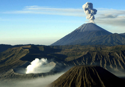
Bromo volcano (East Java, Indonesia)
12h02 PM | Age: 2 days
The VAAC Darwin reports an ash plume from Bromo's eruption rising to 26,000 ft (ca 9 km) drifting 90 nm NW reaching Surabaya. A low-level plume at 10,000 ft (ca. 3 km) is drifting 20 nm SE.10h24 AM | Age: 4 days
Mild explosive activity continues at Bromo volcano, with a sustained plume of ash reaching 400-800 m above the crater and incandescent material visible at night, according to local news sources.
CVGHM reported about the strong activity on 5 February that volcanic bombs were ejected to up to 1.2-1.4 km distance, and up to 500 m distance in the following days. Roaring and booming noises were noted. Ash fell at the Bromo observation post, and in nearby villages including Ngadirejo (10 km WNW), Sukapura (14 km NE), and Sumber (18 km E).
Residents and tourists were not permitted within a 2-km-radius of the active crater.
(abbreviated from the Smithsonian/USGS Weekly Volcanic Activity Report 2-8 February 2011).
Bárdarbunga volcano (Iceland)
Another Icelandic volcano might be preparing itself for a new eruption. Bárdarbunga, a large central volcano at the NW end of the massive Vatnajökull ice cap, has recently shown increased seismic activity, the Icelandic Met Office is reported in an article of the Telegraph. These could be precursors to new activity. After all, Bárdarbunga is one of Iceland's most active volcanoes and is located quite on the center of the Icelandic hot spot. Its last eruption was in 1902-03.
Besides ash clouds, a main hazard would be jökulhlaups (glacier floods) likely to occur with a next eruption of Bárdarbunga.
This is getting to biblical preportions and a sure sign of polar reversal or in other words POLESHIFT , there is no records of this phenominal act but the bible did have the floods and noahs arc which was associated with polar reversal.
FUEGO Guatemala
during 2-3 February Fuego produced 27 explosions with ash plumes that rose 300-500 m above the crater and drifted 7 km W and SW. The explosions generated shock waves detected as far away as 5 km W and SW, in Sangre de Cristo, Panimache I and II, and Morelia. Block avalanches descended the Santa Teresa, Taniluyá, Cenizas, and Trinidad drainages to the SW. During 6-8 February explosions produced ash plumes that rose 500 m above the crater and drifted W and SW. At night incandescence was observed emanating from the crater and explosions sometimes ejected incandescent material 100 m above the crater rim.
KIRISHIMA Kyushu
According to a news article, explosions on 2 February from Shinmoe-dake (Shinmoe peak), a stratovolcano of the Kirishima volcano group, disrupted flights to Tokyo. The article also noted that JMA widened the restricted zone to a 4-km-radius around the crater. About 600 people from Miyazaki (55 km E) had evacuated.
Based on reports from JMA, analyses of satellite imagery, and pilot observations, the Tokyo VAAC reported that during 2-8 February ash plumes rose to altitudes of 1.5-4.6 km (5,000-15,000 ft) a.s.l. and drifted SE. On 3 February, a pilot noted that an ash plume rose to an altitude of 9.1 km (30,000 ft) a.s.l. and drifted NE.
According to JMA, scientists observed Shinmoe-dake during an overflight on 6 February and noted that the lava dome was about 600 m in diameter, similar to observations from four days prior. Gas plumes rose from the edges of the lava dome, from multiple areas on the E side of the dome, and from a central vent. Ash plumes rose 1.5 km above the crater rim and drifted SE.
Geologic Summary. Kirishima is a large group of more than 20 Quaternary volcanoes located north of Kagoshima Bay. The late-Pleistocene to Holocene volcano group consists of stratovolcanoes, pyroclastic cones, maars, and underlying shield volcanoes located over an area of 20 x 30 km. The larger stratovolcanoes are scattered throughout the field, with the centrally located, 1,700-m-high Karakuni-dake being the highest. Onami-ike and Mi-ike, the two largest maars, are located SW of Karakuni-dake and at its far eastern end, respectively. Holocene eruptions have been concentrated along an E-W line of vents from Mi-ike to Ohachi, and at Shinmoe-dake to the NE. Frequent small-to-moderate explosive eruptions have been recorded since the 8th century.